Introduction
Today, geolocation and geo-positioning have turned into a state that we did not dream about 60 years ago, during the first thoughts about creating an Internet network.
This article was prepared thanks to the IPGeolocation.io
Cartography has turned into a miracle — from insanely large sheets of paper to what fits in the palm of your hand.
Today, maps are used not only to search for a cultural center in Paris, but to be able to find everything:
- nearest hotel
- pharmacy or hospital
- grocery store
- university or school
- Pink Concert venue in San Francisco
The transformation of technology will not stop there. It will be better and more accurate than ever.
Evolution in time
Let's see how the evolution of geolocation began. The journey of this phenomenon begins in ancient times.
Excursion into the past
The ancient Greeks triangulated their location using the location of the stars. They counted stars as their travel guides. Using stars such as Polaris (Northern Star) or Sirius, they could find themselves on long and long journeys.

Fast forward to many years ago, where the first practical radar system was invented by Sir Robert Watt in 1935.
In 1989, the very first GPS satellite was launched in the United States for commercial use.
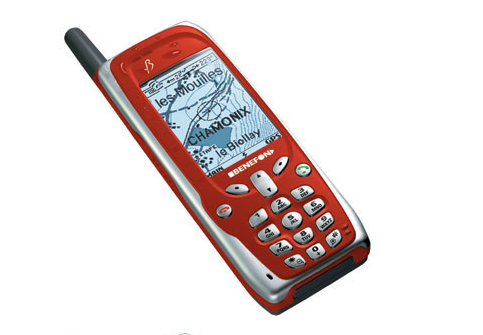
The development of this technology has become fast since that moment. In just 10 years Benefon Inc. became the first company to introduce the first commercially available mobile phone with integrated GPS.
This is the year 2019 and we have come a long way since the times of Benefon.
You can find lost pets with collars, children, parents who have built-in GPS in smart devices.
Now you can find the location of your favorite hamburger and its delivery without getting up from your sofa.
This is how we use this technology individually in everyday life.
Geolocation is used on a much larger scale — by enterprises to track and target the right users to increase sales and reach the right audience of customers.
So, the first order of business and the basic rule of our time: to understand this term on the really necessary and requiring definitions.
What is geolocation?
According to Wikipedia,
“Geolocation is the identification or assessment of the actual geographical location of an object, such as a radar source, mobile phone, base station or any device connected to the Internet. In its simplest form, geolocation involves generating a set of geographic coordinates and is closely related to the use of positioning systems, but its usefulness is enhanced by using these coordinates to determine a significant location, such as street address, zip code.”
In other words, geolocation is your physical network address on the planet.
IPv4 and IPv6 Addresses
IP is an acronym for Internet Protocol. IP address is a uniquely identifiable label for each device connected to a computer network and having distributions by place of registration for the continents (registrars). Or, simply put, IP is your virtual address.
Wherever in the world you use the Internet, you will be assigned an IP address.
IP addresses are formed in their own ranges, which are fixed by regional Internet registrars for different providers and network owners, regulated by an autonomous system (ASN):
American Registry for Internet Numbers (ARIN) — for North America;
RIPE Network Coordination Center (RIPE NCC) — for Europe, the Middle East and Central Asia;
Asia-Pacific Network Information Center (APNIC) — for Asia and the Pacific;
Latin American and Caribbean Network Information Center (LACNIC) — for Latin America and the Caribbean;
African Network Information Center (AfriNIC) — for Africa and the Indian Ocean Region.
When working with IP addresses, you will see two types of IP addresses:
0.0.0.0 is the IPv4 address,
2001:db8:85a3::8a2e:370:7334 is an example of an IPv6 address.
What is an API?
API is short for application programming interface.
This is a set of functions that allows applications to communicate with each other. You have seen sites that allow you to register via Facebook or Twitter (or any external platform). This relationship between this site and Facebook is created using the API.
So, now that we know what geolocation, IP and API are, I present to you the IP Geolocation API.
Geolocation API in practice
The IP Geolocation API is a small piece of code (API) that helps determine the approximate physical location of a user using their virtual address (IP). IP Geolocation is a method for determining the approximate physical location of an Internet-connected device through an address, and the IP Geolocation API is the availability of this method as an API.
IP Geolocation Uses (Overview):
If you are a marketer, you can use the information from this API and direct your marketing efforts in the right and correct direction in order to get a decent result in the interaction.
Online merchants can use IP geolocation to track any potential credit card fraud. This is done by matching the buyer's IP address with the shipping/billing address that he entered.
For example, if the entered shipping address is in India, but the IP address tells us the location of the visitor in Australia, it may be flagged as fraud.
Law enforcement agencies use geolocation to track criminal activity on the Internet and prevent future offenses.
Geofences are a “fence” around content that is allowed to display in certain regions. You may have come across sites that say: «This content is blocked for viewing in your country.»
For example, VK.com is blocked in Ukraine, Jimmy Kimmel’s latest videos are blocked in Southeast Asia, and Pokemon Go was originally allowed to play in the United States (but it was released in more than 60 countries).

Many large e-commerce sellers have successfully used this technology and get really amazing results.
We've compiled a list of some things to show how they do great marketing with IP geolocation.
By integrating the means of geolocation services and combining them with all kinds of SDKs, plug-ins, a situation is created when a high priority is observed specifically for geolocation and it is common for it to receive a larger number of parameters.
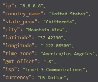
The functionality and possibilities of providing a service in services is simply amazing, for an IP address you can get: hostname, name and code of the continent, name and country code in two formats, country flag, capital, country names, region, region, city, zip code, coordinates (longitude and latitude), country phone code, TLD, list of country languages, type of connection, organization and provider name, currency and its symbol, time zone and current time — this data bag provides a great opportunity to implement such information about IP addresses Your own customers. This is a great asset for those who really need the greatest detail of user data projects and services, receiving a range and summaries on such a scale.
This amount of information provided for the address on the network will help to improve the analytical, statistical and monitoring data about the client in order to improve the targeting of their product or business.
If you want to get much more and create your own metadata package when using geo-services, this is the right option to start using analytical statistics and analysis, as well as just combine auxiliary tools for ease of use, determining and displaying information at the geolocation level.
We sincerely wish to use the truly beautiful and useful wisely, making profit and pleasure from our activities!
